Geography and Climate of Canada: A Comprehensive Overview

Canada, the second-largest country in the world by total area, spans 9,984,670 square kilometers and encompasses a remarkable diversity of landscapes and climates. From the rugged Atlantic coastline to the towering Rocky Mountains, and from the fertile prairies to the vast Arctic tundra, Canada's geography is a testament to the raw beauty and power of nature.

Regional Breakdown

Atlantic Provinces

1. Newfoundland and Labrador

  • Geography: Rugged coastlines, fjords, and the Labrador Peninsula
  • Notable features: Long Range Mountains, Gros Morne National Park
  • Climate: Maritime, with cool summers and relatively mild winters on the coast; colder inland

2. Prince Edward Island

  • Geography: Gently rolling hills, red sandstone cliffs, and sandy beaches
  • Notable features: Green Gables Shore, Confederation Bridge
  • Climate: Maritime, with warm summers and mild winters by Canadian standards

3. Nova Scotia

  • Geography: Peninsula and islands with varied coastal landscapes
  • Notable features: Cape Breton Highlands, Bay of Fundy (world’s highest tides)
  • Climate: Maritime, with warm summers and cold, wet winters


4. New Brunswick

  • Geography: Mix of coastal plains, Appalachian Mountains, and forests
  • Notable features: Fundy National Park, Saint John River Valley
  • Climate: Maritime in the south, more continental inland

Central Canada

5. Quebec

  • Geography: Varied, from Laurentian Mountains to Hudson Bay lowlands
  • Notable features: St. Lawrence River, Gaspé Peninsula, Canadian Shield
  • Climate: Ranges from humid continental in the south to subarctic in the north

6. Ontario

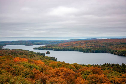
  • Geography: Canadian Shield in the north, Great Lakes-St. Lawrence Lowlands in the south
  • Notable features: Niagara Falls, Great Lakes, Algonquin Provincial Park
  • Climate: Humid continental in the south, subarctic in the far north

Prairie Provinces

7. Manitoba

  • Geography: Transition from prairies in the south to boreal forest and tundra in the north
  • Notable features: Lake Winnipeg, Hudson Bay coastline
  • Climate: Continental, with warm summers and very cold winters

6. Saskatchewan

  • Geography: Predominantly prairie and boreal forest
  • Notable features: Cypress Hills, Lake Athabasca
  • Climate: Semi-arid steppe, with hot summers and very cold winters

6. Alberta

  • Geography: Prairies, foothills, and Rocky Mountains
  • Notable features: Banff National Park, Athabasca Oil Sands
  • Climate: Continental, with cold winters and warm summers; alpine in the Rockies

Western Canada

10. British Columbia

  • Geography: Diverse, with Coast Mountains, Interior Plateau, and the Rocky Mountains
  • Notable features: Vancouver Island, Fraser River, Great Bear Rainforest
  • Climate: Varies from mild, rainy coastal to dry interior and alpine

Northern Territories

11. Yukon

  • Geography: Mountainous, part of the Cordillera region
  • Notable features: Mount Logan (Canada’s highest peak), Kluane National Park
  • Climate: Subarctic, with long, cold winters and short, cool summers

12. Northwest Territories

  • Geography: Diverse, from boreal forest to Arctic tundra
  • Notable features: Great Slave Lake, Mackenzie River, Nahanni National Park Reserve
  • Climate: Subarctic to Arctic, with extremely cold winters

13. Nunavut

  • Geography: Mostly Arctic tundra and islands
  • Notable features: Baffin Island, Ellesmere Island, numerous Arctic islands
  • Climate: Arctic, with long, extremely cold winters and short, cool summers

Major Geographical Features

  1. Mountain Ranges
    • Rocky Mountains: Stretching from British Columbia to Alberta
    • Coast Mountains: Running along the Pacific coast of British Columbia
    • Appalachian Mountains: Extending into New Brunswick and Quebec
    • Laurentian Mountains: Part of the Canadian Shield in Quebec and Ontario
  2. Rivers
    • Lawrence River: Major waterway in eastern Canada
    • Mackenzie River: The longest river system in Canada, flowing through the Northwest Territories
    • Fraser River: Largest river in British Columbia
    • Yukon River: Flowing through Yukon Territory and Alaska
  3. Lakes
    • Great Lakes: Superior, Huron, Erie, and Ontario (shared with USA)
    • Great Bear Lake and Great Slave Lake in the Northwest Territories
    • Lake Winnipeg in Manitoba
    • Thousands of smaller lakes across the Canadian Shield
  4. Coastal Features
    • Atlantic Coast: Characterized by bays, inlets, and islands
    • Pacific Coast: Featuring fjords, islands, and the Inside Passage
    • Arctic Coast: Marked by numerous islands and the Northwest Passage
  5. Plains and Lowlands
    • Interior Plains: Covering parts of Alberta, Saskatchewan, and Manitoba
    • Lawrence Lowlands: Fertile region in southern Quebec and Ontario
    • Hudson Bay Lowlands: Vast wetland area around Hudson Bay

Climate Zones and Their Characteristics

  1. Arctic Climate
    • Location: Northern territories and far northern parts of provinces
    • Characteristics: Extremely cold winters, short cool summers, low precipitation
  2. Subarctic Climate
    • Location: Most of the northern parts of the provinces
    • Characteristics: Long, very cold winters, short mild summers
  3. Cool Continental Climate
    • Location: Southern parts of Prairie provinces, northern Ontario and Quebec
    • Characteristics: Cold winters, warm summers, moderate precipitation
  4. Warm Continental Climate
    • Location: Southern Ontario and Quebec
    • Characteristics: Cold winters, hot summers, high humidity
  5. Pacific Maritime Climate
    • Location: British Columbia coast
    • Characteristics: Mild temperatures year-round, high precipitation, especially in winter
  6. Atlantic Maritime Climate
    • Location: Atlantic provinces
    • Characteristics: Cool summers, mild winters, high precipitation
Need to know more about Geography and Climate?

Get in Touch


    Impact of Climate Change

    Canada is experiencing climate change effects more rapidly than many other regions:
    • Arctic sea ice reduction: Affecting wildlife habitats and northern communities
    • Permafrost thaw: Leading to infrastructure challenges in northern regions
    • Increased forest fire risk: Particularly in western provinces
    • Changes in precipitation patterns: Affecting agriculture and water resources
    • Rising sea levels: Threatening coastal communities, especially in Atlantic Canada

    Influence on Human Settlement and Economy

    • Population concentration: About 90% of Canadians live within 150 km of the US border
    • Resource-based economies: Mining in the Shield, oil in Alberta, forestry in BC
    • Agriculture: Prairies are the breadbasket of Canada
    • Urban development: Major cities located in southern regions with milder climates
    • Transportation challenges: Vast distances and harsh climates affect infrastructure development


    Canada’s geography and climate are integral to its national identity, shaping not only the physical landscape but also the country’s culture, economy, and way of life. From the frozen expanses of the Arctic to the temperate rainforests of the Pacific coast, Canada’s natural diversity continues to inspire and challenge its inhabitants. As the country faces ongoing environmental changes, understanding and adapting to these geographical and climatic realities will be crucial for Canada’s sustainable future.

    Other support information for

    Life in Canada